Heritage Adventures
Click on image to play video
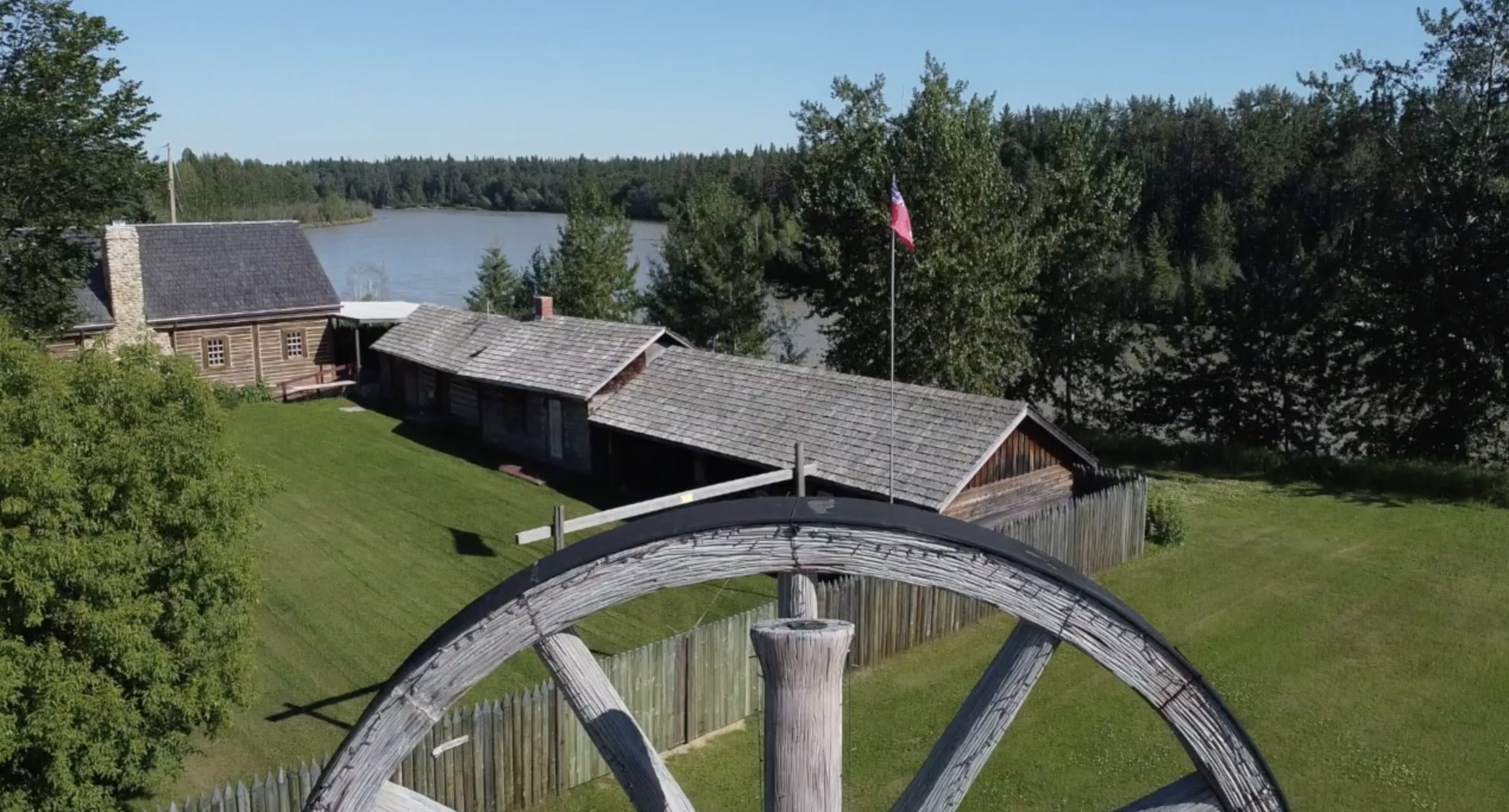
Fort Assiniboine Museum
The museum is constructed in the classic Hudson’s Bay-style of a trading post and reflects the fur-trading times that helped to establish the area.
Artifacts on display outline the progression and development of Fort Assiniboine, which is the second-oldest fort in Alberta.
The famous location is mentioned in early historical records dating back to the 1700s.
During the Hudson Bay Era (1823-1877), the site was named Fort Assiniboine presumably after the Assiniboine Indians, and was used as a supply and transportation point.
The museum is open to visitors during the summer months and is a great afternoon retreat to learn about some of the key historic movements that helped shape the Woodlands County area and Western Canada.
About Woodlands County
Click on image to play video
Klondike Trail
During the late 1800's and the early 1900's, Barrhead played an important role in the settlement of north-western Alberta. Highway 33, known as the Grizzly Trail, follows the original Klondike Trail, which was the shortest route to the Yukon during the Gold Rush years. Once established, this route was key to the settlement of the Peace River region. The old Barrhead town site, 3 km north of the present Town Centre, was a frequent stop over for the Klondikers and others who needed supplies for the rigorous journey north.
Originally established in 1906, Barrhead's position as a major trade centre on the historic Klondike Trail gave it a significant role in the settlement of north-western Alberta. It was a vital link in the trade route from Fort Edmonton to the Yukon.
Map (Historic Pembina River Crossing)
Map (Fort Assiniboine Sandhills Staging Area)
About the County of Barrhead
Fallen Four Memorial Park
On March 3, 2005, four local RCMP were killed in an ambush a few miles northeast of Mayerthorpe. This Park was officially opened on July 4, 2008 to honour their memory and the memories of all peace officers killed in the line of duty.
In 2021 The Mayerthorpe public Library moved into the building at the park. The facility also continues to operate as the Tourist Information Centre.
Guided tours are available by appointment.
About Mayerthorpe
Click on image to play video
Canadian Tractor Museum
The Canadian Tractor Museum features more than 90 restored tractors, 30 stationary engines, hundreds of toy tractors and implements, and many other artifacts all relating to our agriculture heritage. It preserves, portrays, and interprets a Canadian point of view on the history of tractors and related equipment.
They host private tours, birthday parties, social functions, office & board meetings, and numerous other events year round.
About the Town of Westlock
Klondyke Ferry
As one of the few remaining cabled ferries in Alberta, the Klondyke Ferry it a true northwest adventure. It’s a free 10-minute ride for pedestrians, cyclists and motorized vehicles to cross the scenic and historic Athabasca River.
A picturesque meadow welcomes you at the east landing with a self-registration, 13-unit campsite area. The west landing features the Fort Assiniboine Sandhills Provincial Park with amazing views, hiking, horseback riding, and a section of the historic Klondike Trail.
The Klondyke Ferry operates 6:30 am - 11:30 pm, from early May to Mid-November.
About the County of Barrhead
Crocket House Cafe
Located in an impressive heritage building (one of the oldest buildings in Mayerthorpe), Crockett House Cafe features coffee, lattes, breakfast, soup, sandwiches and baking. Come experience the cozy community atmosphere.
About Mayerthorpe
George Pegg Botanic Garden
The original Pegg family homestead is a designated provincial historic resource, open to the public to learn about George Pegg’s botanical work. Open June through August, a variety of events are held during the summer.
About Lac Ste. Anne County
Alberta Beach Museum and Heritage Village Park
The Alberta Beach Museum and Heritage Village Park, is located at the heart of Alberta Beach, just a block and a half away from the main beach area.
Heritage Village Park was started by the museum as a way of sharing our story from times gone by. It started with a vision from members and a donation of the original one-room, Grasmere School.
Following the restoration of this building to its original splendor, more buildings were added to the site and completely restored. You can now come to see the Jail, Nurse’s Station, Summer Cottage, Log Cabin, Trinity Chapel, Teacherage, and of course the original Train Station. Be sure to visit the Heritage Village during the summer.
About Alberta Beach
Rochfort Bridge Pioneer Museum
The Rochfort Bridge Pioneer Museum is located just off Highway 43 in Rochfort Bridge, Alberta. The complex includes an original rural schoolhouse, an original pioneer log cabin and a replica blacksmith shop, as well as the museum itself.
The Lac Ste. Anne Historical Society was formed in 1959. Their mandate has been to "Collect, Preserve, Research, and Exhibit our Heritage through the Pioneer Museum, associated building and grounds located at Rochfort Bridge".
Open June – September,
About Lac Ste. Anne County
Click on image to play video
Strongheart Historic Site
The present County of Barrhead has been made up of many local improvement districts and municipalities. Prior to the formation of a local government, the area from Dunstable to Fort Assiniboine was served by two main access roads from the City of Edmonton. The two roads leading out of Edmonton were the Athabasca Trail heading northeast and the Klondike Trail heading northwest, used by the gold prospectors in 1898.
The Klondike Trail Society has worked on mapping and locating some of its historic sites in the County of Barrhead. The Strongheart Historic Site is located on Township Road 610 and Range Road 43. There is a cairn, graves and a trail, as well as the remains of an old cabin.
About the County of Barrhead

Geographic Centre of Alberta
Here’s something you probably didn’t know. The geographic centre of Alberta is nowhere near Edmonton! It’s actually in Woodlands County, between Fort Assiniboine and Swan Hills. Visit the area for interesting hiking and wildlife sightings.
About Woodlands County

Barrhead Centennial Museum
Established in 1967, the Barrhead Centennial Museum has collected a large number of artifacts that reflect the unique history of the Barrhead area: from life in a pioneer farming community, to the schools, churches and community halls that dotted the landscape, to the stories of merchants, school teachers, lawmen and rogues.
The museum’s displays are varied and diverse, including a unique stone grain grinder as well as the Werner Collection which features a number of mounted animals from Mozambique.
Finally, the museum’s archives hold a complete collection of the earliest local newspapers, as well as marriage and funeral records, community history books, and a large number of photographs.
About Town of Barrhead

Onoway Museum
The Onoway Museum is located in the Old Brick School, vacated as an elementary school in June 2007. Beaupré School was a two-room brick school built in 1921. Over the years this building grew and evolved into Onoway Elementary School with a school population of 430 when it was decommissioned in 2007.
The Old Brick School gained a new life as Onoway Museum, preserving the history of the school and the surrounding community. The four classrooms feature themed exhibits: School Room, Country Home, Main Street, and Community Life/Farm. These exhibits tell the story of the founding, settlement, and development of this part of north-central Alberta.
About Onoway

Westlock Pioneer Museum
The Westlock Pioneer Museum contains thousands of objects, many of them donated by the descendants of early settlers in the Westlock area, including such smaller surrounding communities as Clyde, Dapp, Linaria, Busby, Pickardville, Pibroch, Jarvie and Flatbush.
The museum contains everything from early pioneer farm equipment and vehicles to wedding dresses and kitchen utensils, all evocative of the lives of the pioneers who built a community in the area.
About the Town of Westlock

Wabamun and District Museum
The Wabamun & District Museum Society was established in 2007 to preserve for the public benefit, the natural, historical, industrial and cultural heritage of the village of Wabamun and communities surrounding Wabamun Lake, from the early 1800s to the present. The museum officially opened in July 2009.
About Wabamun